Archive for November, 2005

Repairs Continue on the Irving Johnson

Posted by John Callender on November 30th, 2005 at 9:22 pm

The Irving Johnson aground off Channel Islands Harbor

I’ve talked before about how a grounding is the sort of thing that’s guaranteed to get a boater’s attention, and if the grounded vessel is a tall ship, even a smallish one, the interest level is going to be that much higher. That was certainly the case back in March of this year, when the Irving Johnson, a 90-foot replica brigantine launched in 2003, went aground just south of the entrance to Channel Islands Harbor. The boat remained hard aground for a couple of days before she could be refloated. Here’s an article on the event from Ocean Navigator Online: Sail training vessel runs aground off California coast. And here’s another, somewhat more breathless, account from the CBS News web site: ‘Horrifying’ spring break at sea.

Now The Log’s Coty Dolores Miranda has written an article detailing some of the ongoing repair work being done on the boat in Ventura Harbor: Irving Johnson reemerging, slowly but surely. There’s a fair amount of detail about the volunteers helping the Los Angeles Maritime Institute (LAMI) to bring the boat back to tip-top condition.

The photo above was taken by amateur photographer and Coast Guard Auxiliary member Michael Brodey, and is used here with his permission. In response to my request, he wrote back, “It just so happens that that particular photo won first place in the Coast Guard Auxiliary’s Public Affairs Photo Contest this year.” Congratulations, Mike; it’s a great photo.

VOR: ABN AMRO 1 Sets 24-Hour Record; Ericsson’s Keel Goes ‘Bang’

Posted by John Callender on November 29th, 2005 at 7:45 pm

ABN AMRO One in spray

The four leaders in the Volvo Ocean Race are stretching apart in the final run to the Leg One finish at Cape Town, with first-place ABN AMRO One setting a new 24-hour monohull distance record of 546 nautical miles. From the official VOR site: Fastest on the planet.

Meanwhile, aboard Ericsson, currently in fourth place, last night got very exciting at one point. Again from the official site: Bitter blow for Ericsson.

“We were reaching on starboard tack at a speed of 20 knots,” explains Ericsson skipper Neal McDonald, “The boat was fully loaded, but these were normal sailing conditions. At 0045 GMT, we suddenly heard a loud bang. We immediately stopped the boat and took the mainsail down to investigate the problem. There was no visible damage, but it was obvious that the keel was flopping from side to side! After a few minutes of work, Richard Mason managed to lock the keel in one safe position. We are now sailing towards Cape Town in a much-reduced capacity.”

Photo: ABN AMRO One gives crew the firehose treatment in the Atlantic. Photo courtesy of the official ABN AMRO site.

Animated Wind Maps Are Up in Beta Form

Posted by John Callender on November 27th, 2005 at 10:29 am

wind map sample

I’ve been working on this for the last week or so; it’s still a little rough, but I think it’s far enough along to be worth unveiling. Anyway, check it out: Southern California wind observations.

I’m currently producing a static map showing the latest hour’s wind data from NOAA’s National Data Buoy Center; in addition there are animated maps showing the previous 6, 24, and 72 hours. The maps are updated at 30 minutes past the hour, by which time most of the buoys have uploaded their previous hour’s data.

On my to-do list are the following:

  • Fiddling with the little wind icons to make them antialias better.
  • Adding some sort of analog time display to make it easier to track the passage of time in the animations.
  • Adding additional maps for other locations (the buoy data at NDBC covers all US coastal waters, as well as a number of other regions in other parts of the world).

I think it’s pretty cool, in terms of the concept, at least, and I’ll keep working on improving the execution. I’d be interested in getting feedback on how the wind maps could be improved, either privately via email at feedback@socalsail.com, or publicly using the weblog’s comment form.

Thanks!

Positions in Flux at the Front of the VOR Fleet

Posted by John Callender on November 26th, 2005 at 10:04 am

Brasil 1 at Fernando de Noronha

For the four boats at the front of the Volvo Ocean Race fleet, it’s been a seesaw battle over the last few days. The boats have been in lighter wind as they try to get south; now they’re turning the corner for the finish line in Cape Town.

For a day or so Brasil 1, which had chosen to take an easterly line, took the lead (on paper at least). Now, though, the more-southerly ABN AMRO One has picked up the wind and turned east, and retaken the top spot. The computer rankings have ABN AMRO Two 50 miles back, Brasil 1 6 miles behind them, and Ericsson another 15 miles behind them. From the official site: Position maps and Turning the corner.

More discussion of what’s going on from BangTheCorner.com (Who’s winning? Go on!)

Photo: That’s Brasil 1 during the mid-leg rounding of Fernando de Noronha; more images available from their official team site.

More Free Charts

Posted by John Callender on November 26th, 2005 at 9:35 am

Maptech, the company that used to sell NOAA’s raster charts, is now offering its own free online distribution of them: Free boating charts. The interface seems to be a little slicker than the one at NOAA’s site, so go thou and download likewise.

Downloadable Raster Charts Available Free from NOAA

Posted by John Callender on November 22nd, 2005 at 6:59 pm

Catalina\'s West End

I wrote previously about NOAA’s intention to make raster versions of their nautical charts available over the Internet (Free raster charts from NOAA? Not yet, sadly). Well, guess what? The day is here! Woohoo!

From the Office of the Coast Survey: NOAA raster navigational charts.

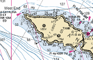
A fundamental tool of marine navigation, NOAA’s Raster Navigational Charts (NOAA RNCs) are produced by scanning at high resolution the original color separates, which are used to print the paper charts.

I feel a little like Steve Martin’s character in The Jerk, when he goes running down the street shouting, “The new phone book is here! The new phone book is here!” I have a long history with NOAA’s charts. As a teenager I was a hard-core navigation geek. I read Bowditch cover-to-cover, and used to lobby my Dad for upgraded charts to replace the tattered ones (some of them older than I was) that he kept on his boat. I loved those charts. Even now, when GPS has rendered the close, personal relationship I used to have with them somewhat obsolete, I still have a soft spot for them. The thought of being able to just sit in my home and download every single one of them (well, almost every single one; the site mentions a few that have problems currently), is just… I don’t know. Something.

Something good. :-)

Elaine Dickinson, managing editor of BoatUS Magazine, was kind enough to send me an email alerting me to the availability of the charts at the NOAA site. The files are available via a fairly clunky Java-based interface, and arrive in BSB format, which apparently is a format developed by Maptech, the former vendor of the charts whose licensing agreement recently expired.

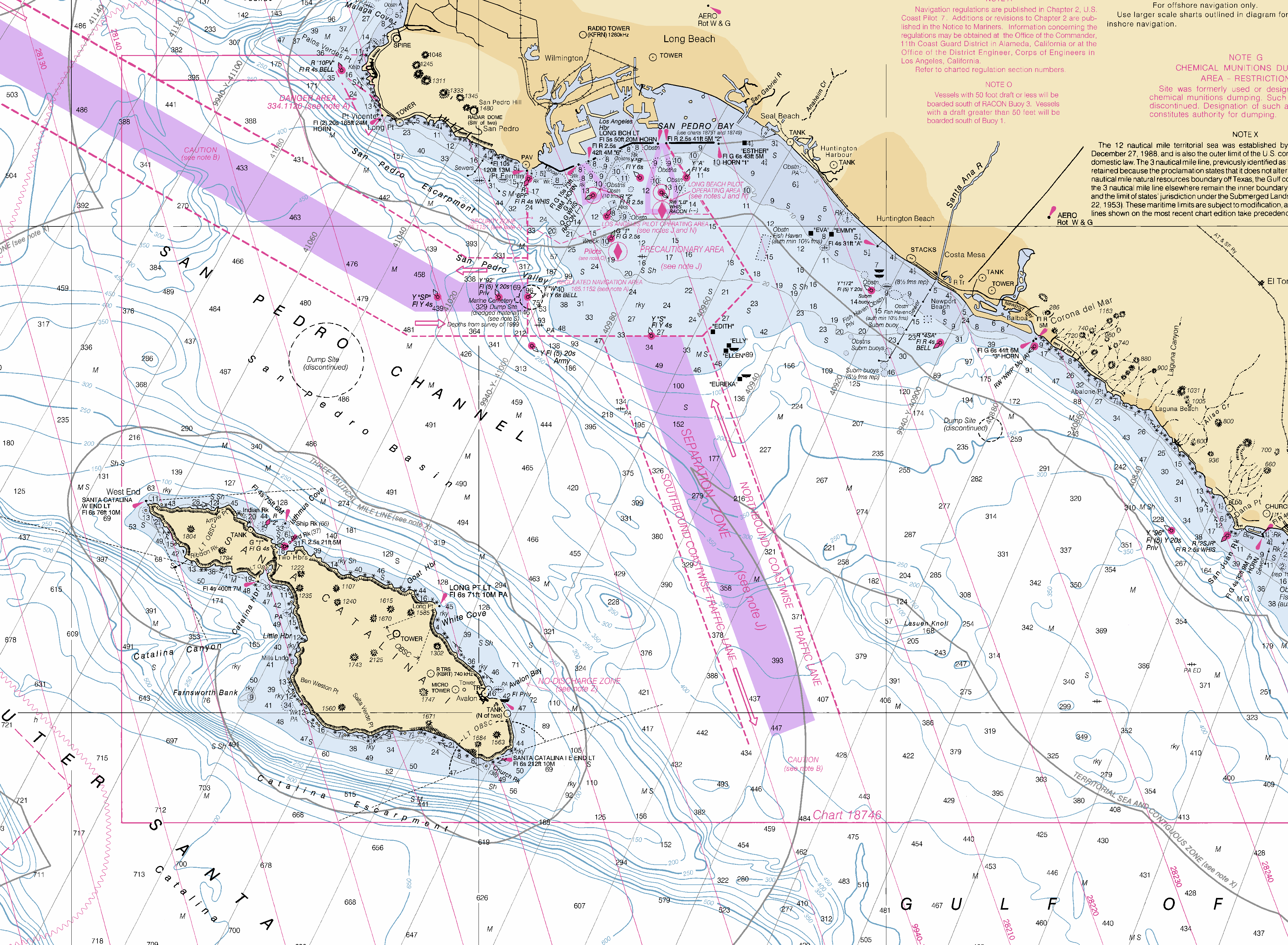
I was able to find a nifty open source library called libbsb to read the charts, and shortly thereafter I was scrolling happily through a 12,451 x 9,390 pixel PNG of 18740, San Diego to Santa Rosa Island, a chart I’ve probably spent more time with than any other. The image above is a reduced version of one part of it; here’s a full-scale sample of it to give you an idea of what it’s like.

Apparently the program of making the charts available is still in the beta stage. At least, that’s the impression I get from the following email from Captain Jim Gardner, chief of the Marine Chart Division at NOAA:

NOAA’s Free Raster Chart Server is now up at:
http://Nauticalcharts.noaa.gov/

There is a limit of 100 charts that can be selected and downloaded at one time. With selection of any chart you can get:

1. The BSB formatted raster chart, updated for most recent Notice to Mariners (NTMs).

2. A cumulative patch file of all NTMs released since the last edition of the chart has been published. This file is intended to bring a current edition raster completely up-to-date.

3. Or both

Note: The server has been experiencing occasional downtime recently. Please try again if you are having problems.

Baring any serious problems we hope to announce this on December 1.

I’m looking forward to figuring out how I can best integrate the charts with the offerings on this site; at a minimum, you can expect to find some smallish chunks of them adorning the Locale pages in the Buyer’s Guide.

So, did I mention how excited I am about this? Woo!

VOR: ABN Amro One Wins Mid-Atlantic Gate

Posted by John Callender on November 22nd, 2005 at 6:31 am

ABN AMRO One does a bow-plant

ABN AMRO One has led the way through the mid-Atlantic “gate” of the Volvo Ocean Race’s first leg at the Ilha de Fernando de Noronha. Details from Yachting World: First points for ABN AMRO 1.

Ericsson, which has been coming on strong in the last few days, was second through the gate. Combined with the points from her in-port win in Spain, that means that if the current positions hold up at the finish of Leg One in Cape Town, Ericsson will actually have a one-point lead over ABN AMRO One at that point.

Still, it’s early to be talking about finishing positions for Leg One. There’s still a lot of very rough water for these boats to go over (or through, as in this very cool image of ABN AMRO One by Jon Nash, and run here courtesy of the offical ABN AMRO site).

Geronimo Sets New Transpac Record

Posted by John Callender on November 21st, 2005 at 5:00 pm

Geronimo close hauled

The 110-foot trimaran Geronimo has successfully posted a new record for the Los Angeles-to-Honolulu passage. Details available from superyachting.com: Los Angeles – Honolulu challenge.

Four days, 19 hours, 31 minutes and 37 seconds (subject to ratification) after crossing the start line off Los Angeles, Capgemini and Schneider Electric’s maxi trimaran Geronimo has set a new record for the transpacific Los Angeles to Honolulu Challenge . Crossing the finish line off Diamond Head in Hawaii under a moonlit night sky, at 4:36am local time (US Hawaii) November 18 and 14 36 40 UTC November 18, Geronimo and her men now have a hat trick of WSSRC sailing speed records.

According to the information at superyachting.com, Geronimo should have now completed her 2-day stopover in Honolulu, and be bound (again) for San Diego. I assume the return journey will be somewhat slower than the just-under-5-days it took them going out, but “slow” is very much a relative concept with this boat.

Profile of Carl Eichenlaub

Posted by John Callender on November 17th, 2005 at 8:03 am

There’s a nice write-up about Carl Eichenlaub in the latest issue of The Log: Carl Eichenlaub takes sailing to a new level.

I’ve never met Eichenlaub, though as a kid growing up racing in Southern California I competed against him a lot. His two tonner Cadenza, which was way ahead of its time in terms of having bold graphics spelling out the boat’s name over most of the hull, was frequently in the same part of the racecourse as my dad’s Columbia 52 Victoria, which tended to be depressing since we owed them time. But the boat was certainly fun to look at.

Geronimo on Track for Transpac Record

Posted by John Callender on November 16th, 2005 at 8:50 pm

Geronimo start

After starting off LA on Saturday, November 12, the 110-foot trimaran Geronimo encountered 12 hours of light winds before returning to port and re-starting on Sunday. The boat has been averaging 25 knots since then, and is currently 702 miles from the finish line in Honolulu. Details from SuperYachting.com: The LA to Honolulu challenge.

Over the last 24 hours the Capgemini and Schneider Electric trimaran Geronimo has been eating up the miles as the Franco American crew pull out all the stops to break the current transpacific sailing record that stands at five days, nine hours, 18 minutes and 26 seconds set in 1997.

Updated information received from onboard Geronimo is that for the four hours from 13 17 to 1701 November 16 UTC the boat had covered 86.25 miles averaging 23 knots boat speed point to point.

The giant ocean record breaker has 822 miles to go to cross the finish line and if all the crew can maintain a 14.80 knots average boat speed from their current location to the finish line they will have their third speed sailing record in four months.


Weblog Home | Buyer's Guide | Weather | FAQ | Contact