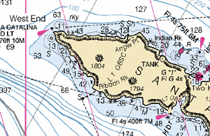
Downloadable Raster Charts Available Free from NOAA
I wrote previously about NOAA’s intention to make raster versions of their nautical charts available over the Internet (Free raster charts from NOAA? Not yet, sadly). Well, guess what? The day is here! Woohoo!
From the Office of the Coast Survey: NOAA raster navigational charts.
A fundamental tool of marine navigation, NOAA’s Raster Navigational Charts (NOAA RNCs) are produced by scanning at high resolution the original color separates, which are used to print the paper charts.
I feel a little like Steve Martin’s character in The Jerk, when he goes running down the street shouting, “The new phone book is here! The new phone book is here!” I have a long history with NOAA’s charts. As a teenager I was a hard-core navigation geek. I read Bowditch cover-to-cover, and used to lobby my Dad for upgraded charts to replace the tattered ones (some of them older than I was) that he kept on his boat. I loved those charts. Even now, when GPS has rendered the close, personal relationship I used to have with them somewhat obsolete, I still have a soft spot for them. The thought of being able to just sit in my home and download every single one of them (well, almost every single one; the site mentions a few that have problems currently), is just… I don’t know. Something.
Something good. :-)
Elaine Dickinson, managing editor of BoatUS Magazine, was kind enough to send me an email alerting me to the availability of the charts at the NOAA site. The files are available via a fairly clunky Java-based interface, and arrive in BSB format, which apparently is a format developed by Maptech, the former vendor of the charts whose licensing agreement recently expired.
I was able to find a nifty open source library called libbsb to read the charts, and shortly thereafter I was scrolling happily through a 12,451 x 9,390 pixel PNG of 18740, San Diego to Santa Rosa Island, a chart I’ve probably spent more time with than any other. The image above is a reduced version of one part of it; here’s a full-scale sample of it to give you an idea of what it’s like.
Apparently the program of making the charts available is still in the beta stage. At least, that’s the impression I get from the following email from Captain Jim Gardner, chief of the Marine Chart Division at NOAA:
NOAA’s Free Raster Chart Server is now up at:
http://Nauticalcharts.noaa.gov/There is a limit of 100 charts that can be selected and downloaded at one time. With selection of any chart you can get:
1. The BSB formatted raster chart, updated for most recent Notice to Mariners (NTMs).
2. A cumulative patch file of all NTMs released since the last edition of the chart has been published. This file is intended to bring a current edition raster completely up-to-date.
3. Or both
Note: The server has been experiencing occasional downtime recently. Please try again if you are having problems.
Baring any serious problems we hope to announce this on December 1.
I’m looking forward to figuring out how I can best integrate the charts with the offerings on this site; at a minimum, you can expect to find some smallish chunks of them adorning the Locale pages in the Buyer’s Guide.
So, did I mention how excited I am about this? Woo!
