Archive for November, 2005

VOR: ABN AMRO 1 Leads; Details on Pirates, Movistar Breakdowns

Posted by John Callender on November 16th, 2005 at 8:25 pm

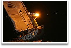
movistar

In the Volvo Ocean Race, the four boats that have not yet suffered any serious breakdowns are still very close together, with ABN AMRO One having an 11-mile lead on Brasil, then Ericsson 1 mile back, and ABN AMRO Two 2 miles back from there. See the official VOR site’s position maps page for details.

Five hundred miles astern, Sunergy is back on the course and racing, though at a significantly slower speed than the boats in the lead pack. And back in Portugal, some really interesting news has come out regarding the breakdowns to movistar and Pirates of the Caribbean, neither of which will be rejoining this leg.

An article from the Telegraph has extensive discussion with Paul Cayard about just what went wrong on Pirates — and it doesn’t sound pretty: Cayard fears for Volvo 70 safety.

Instead of having a keel with a hinge on the outside beneath the hull, like the Open 60s competing in the Transat Jacques Vabre, the Volvo 70s have their pins inside the hull. This leaves a door-sized hole in the hull bottom.

The box – dubbed by Cayard the “fish bowl” because it has an inspection window – sits over the hole in the hull and the hydraulic rams pass into it, sealed by industrial-strength gaiters.

Pirates’ problem was that the fairings are meant to seal the hull bottom. When one fell off, it was not just a question of lost speed through increased drag but of the entire integrity of hull depending on the “fish bowl”, which was not designed to withstand the tons of pressure that were building up inside it.

More info on the Pirates team is available in this update from Cayard at Yachting World’s site: We have now been in port for 36 hours…

Over at movistar, the damage to the hull and appendages that was revealed when they hoisted the boat out of the water has led the team to conclude that they must have hit something big — like a container. More details from the official VOR site: Bad, but not quite as bad.

Again, more detail is available in this item from Yachting World: movistar damage caused by collision.

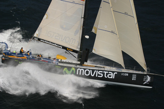
Photo: movistar in happier days. Photo by Sally Collison, http://www.sallycollison.com.
Geronimo Tries for Transpac Record

Posted by John Callender on November 15th, 2005 at 6:49 am

Geronimo

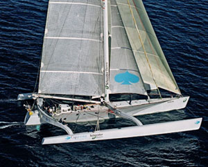
The Log’s Marisa O’Neill has written an interesting article about Geronimo, the world’s largest trimaran, which is in our local waters (Update: er, was in our local waters — she left on the 13th) in anticipation of an attempt on the Transpac-course record: Trimaran eyes Honolulu record.

The 110-foot maxi trimaran Geronimo – fresh from Tahiti – will briefly make San Diego her home before attempting a record-breaking run to Honolulu, planned for next week.

Geronimo sailed into San Diego Bay at about 8 a.m. November 6 after sailing 4,000 miles in 12 days from Tahiti. She will stay at Driscoll Boat Works on Shelter Island while she prepares to break the Transpac speed record of 5 days 9 hours 18 minutes and 26 seconds.

“We want to make her very light for this record,” French skipper Olivier de Kersauson said. “Then we’ll go to Hawaii, stop two days – no more – then come back.”

Upon her return, Geronimo will remain at Driscoll’s until January. Then it’s on to San Francisco, Yokohama and Hong Kong.

At first I didn’t have a good sense of the boat’s scale from that image. When I looked closer, though, and realized that the boat is twice the length of the largest boat I’ve ever sailed on, I said, “whoa.” That would be something else to sail on — or even to see passing by on the water. Look quickly, though; she isn’t going to be there for long. :-)

VOR: Lead Changes, Fire, Men (Intentionally) Overboard, and Sunergy Heads in for Repairs

Posted by John Callender on November 14th, 2005 at 10:20 am

Brasil 1

It’s been a hell of a day at sea for the VOR racers, apparently. From the official site:

In an audio interview at 1230GMT, Ericsson navigator Steve Hayles told the Volvo Ocean Race web site that the boat was stopped in the water and crew members Jason Carrington and Richard Mason were in the water cutting away ropes from the keel and rudder. Thirty hours ago, during the first night, Ericsson had what Hayles described as an issue with a sail and a halyard, and had been sailing since with the debris hanging off the appendages. It was only now that the conditions were judged safe enough to put the swimmers in the water to resolve the problem.

Mike Sanderson, skipper of ABN AMRO ONE spoke to Race Headquarters at 1200 GMT and shocked radio reporter Guy Swindells with a very matter of fact report of a fire on board. Apparently a bolt had dropped into the battery box and lodged between a battery terminal and the carbon fibre structure. Carbon fibre is conductive and the resulting short circuit took out the wiring and systems in navigaton, communications and the media station. Once the fire was controlled, navigator Stan Honey, an acknowledged electronics expert in the field of TV and films, and not just an offshore navigator, has managed to re-wire the damaged areas so that they are now able to communicate and use their electronic navigation systems.

Meanwhile, Sunergy, the Australian team whose finances, and partcipation, were in doubt up until the last days before the start, has suffered a failure of the mainboom gooseneck, and is reportedly heading into port for repairs. More on the carnage in this Times Online article: Volvo boats crippled by raging seas.

At the front of the fleet, it’s currently a seesaw battle between Brasil 1 and ABN AMRO One, with Ericsson and ABN AMRO Two slightly farther back.

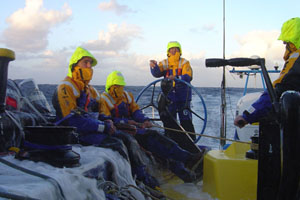
Photo caption: Water flows over the side deck into the cockpit of Brasil 1. ©Brasil 1.

‘Blue Law’ Runs Aground in Newport Harbor Entrance

Posted by John Callender on November 14th, 2005 at 9:28 am

There was an interesting account in the latest issue of The Log about the grounding of Blue Law, a Hunter 54 that got stuck on a sandbar near the entrance to Newport Harbor on November 5: Sailboat runs aground in Newport Harbor entrance.

“I had his crewmembers go from the bow to the stern and back and forth to try to rock the boat to get it off the sand. I was pulling so hard I was afraid I would break the hawser,” Gardner said. “This is the most exciting tow I’ve had in a while. I felt that if I didn’t get the boat off the sand in about five minutes, it would be stuck there for quite a long time.”

Southern California tends not to have the extensive shoals that East Coast and Gulf sailors learn to deal with; groundings around here are relatively uncommon. But we do have little patches of sand here and there that claim the occasional victim, and acquire a bit of local notoriety. I’ve run aground in San Diego Bay off the southern tip of Shelter Island, in the Oceanside Harbor entrance, and in King Harbor in that little corner between the yacht club and the breakwater. I never ran aground (so far) in Newport Harbor, but I haven’t spent much time there, aside from coming in the night before the Ensenada Race a few times.

Pirates, Movistar Out for Repairs; ABN AMRO Boats Lead VOR

Posted by John Callender on November 13th, 2005 at 10:25 am

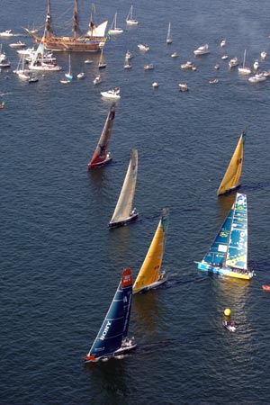
VOR start

The Volvo Ocean Race is under way, and two of the seven boats are already headed to port for repairs involving the hydraulic canting keels. From Yachting World: Drama on leg 1.

Paul Cayard’s Pirates of the Caribbean was understood to have sprung a leak which had seriously damaged the electronics aboard their Volvo 70. According to a report on the official web site:

‘The boat had lost computer control of the keel hydraulics and that as a result, the keel was not operational, compromising the racing ability of the boat, though not its safety. Falmouth Coastguard MRCC was informed, and told that the boat was not in danger and was heading for Cascais in Portugal.’

Aboard Movistar the problems were understood to be more serious. Again, according to reports on the Volvo site:

‘….the boat [Movistar] had fractured a keel ram shelf, the support that carries the fixed end of one of the massive hydraulic rams that actuate the swinging keel.

‘Shortly after the original incident, however, the boat reported further problems. This more serious damage caused Bouwe Bekking, movistar’s skipper to report, “The load on the one ram must have been huge, as the main bulkhead buckled badly. No other option than to head to port as it is not safe to carry on.’

The team are understood to be heading towards Cadiz to assess the damage.

More on the Pirates and Movistar problems from the official VOR site: Unlucky for some.

Meanwhile, the ABN AMRO boats have done a good job of putting to rest the ‘too slow’ worries from the in-port race; as winds have picked up they’ve taken the lead, with ABN AMRO Two in first place and ABN AMRO One 10 miles back. Again from the official site: Seriously hardcore.

Photo by Oskar Kihlborg.

60-Foot Tris at 50% Attrition in Transat Jacques Vabre

Posted by John Callender on November 12th, 2005 at 6:44 am

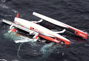
Orange Project capsized in Transat Jacques Vabre

A nasty storm a couple of days ago in the Bay of Biscay, followed by ongoing mayhem from strong tradewinds, have knocked out 5 of the 10 60-foot trimarans competing in the doublehanded transatlantic race currently under way between Le Havre, France, and Bahia, Brazil.

Here’s a writeup from Latitude 38 with aerial photos of the capsized Orange Project and Foncia: Snap, crackle and pop at Transat Jacques Vabre.

As if starting the biennial doublehanded transatlantic race in 25+ knot, on-the-nose winds and rough seas weren’t enough for the 19 monohulls (Saturday start) and 16 multis (Sunday start), Sunday night a cold front rolled in, blasting primarily the multihull fleet with 35 to 45-knot winds and reported 20-ft seas. In the wee hours of Monday, EPIRBs went off on the 60-ft trimarans Sodebo and Orange Project. The former snapped off its port ama and capsized. The latter suffered a broken main beam and also went upside down. Three hours later, at 0615, a report came in that Foncia had also capsized. With the retirement of Brossard earlier on Sunday with a cracked main hull, that takes four of the ten 60-ft multis out of the running. The six co-skippers of the three capsized boats were rescued, some more banged and bruised than others but all okay. At this writing, their smashed boats were all either under tow back to land, or about to be.

Later, Groupama-2 pitchpoled (apparently) and capsized (definitely). Here’s a write-up from sail-world.com: At around 1750 GMT tonight, the 60ft multihull Groupama-2

The prevailing conditions at the time were classic Trade wind 25 – 30 knots from the North East. The trimaran was sailing downwind and it is presumed that therefore the hull pitchpoled on capsize but this is not confirmed.

What we do know is that Franck Proffit was at the helm and was thrown violently forward, and has possibly broken his ribs. A helicopter has been sent from the Canaries to the zone to pick up Franck Proffit from the boat in order to give him immediate medical assistance.

Franck Cammas is staying on board in order to commence a salvage operation for the boat with his shore team. Groupama-2 had been pushing hard all day after their 5 hour pit-stop in Santo Porto at Madeira between 0400 – 0900 hrs local time this morning to repair their steering and rudder systems, and had been clocking average boat speeds over 25+ knots.

That brings to 5 (of 10) abandonments in the 60-foot trimarans of the ORMA class. Also retiring have been two of the Open 50 trimarans, and one of the Open 50 monohulls. So far the boats of the remaining class (Open 60 monohulls) have not suffered any retirements.

More info on the ongoing racing is available from the Transat Jacques Vabre official site. You can also check out cool realtime position maps of the survivors at the French-language site http://voile.esrifrance.fr/.

Southern California Shorthanded Sailing Association Champ: Dan Rossen

Posted by John Callender on November 12th, 2005 at 12:19 am

actually, I don\'t know who this is of

SoCal boat broker Len Bose has been working to put together a local shorthanded sailing association, and he’s just announced the winner of the 2005 competition: Dan Rossen.

2005 SCSSA Champion is Dan Rossen.

Dan sailed to 2nd place Ensenada = 4 Points
3rd MDR to San Diego 3
1st Argosy 5
Two Around Catalina

Tim Coker on “MASQERADE”, Kerry Dever on “KAHOOTS”, Len Bose on “ONLY CHILD” and Bruce Anderson on “Chicken Little” were all very close to winning the SCSSA title.

This being the first season of the SCSSA we are going through the concept stages or “growing pains.” Should you wish to drop me a note and tell me you results please do.

Some additional information is in this Sailing Anarchy thread.

As near as I can tell, Bose put this together after the fact, figuring out in retrospect who had “won” based on races that had already taken place earlier in the year. In any event, it’s a neat idea, and I hope he can generate sufficient interest to keep it going.

Thanks to my brother-in-law Justin McJones for sending along the link.

Times of London on Volvo Safety Fears

Posted by John Callender on November 11th, 2005 at 6:23 am

VOR in port race no. 1 start

I was interested by this article from last week’s Times of London about the potential for mayhem in the upcoming Volvo Ocean Race: Global race starts under a cloud of safety fears.

The new Volvo Open 70s could hardly be more of a contrast to Volvo’s safetyconscious designs for the family car market. The boats are only 10ft longer than the old Volvo 60s, which were used in the last race four years ago, but they are much more powerful and much more dangerous.

Capable of exhilarating performance, with a top speed of up to 40 knots, the super-light Volvo 70s demand total concentration from their ten-man crews, with manoeuvres in rough seas having to be precisely choreographed if spectacular wipe-outs are to be avoided.

The new boats are more complex than the 60s and include hydraulically controlled keels that swing through an arc of 40 degrees either side of the centre line, giving the yachts extra lateral stability, plus daggerboards either side of the mast to prevent the boats slipping sideways.

Conceptually, it makes all kinds of sense. In flat water, under ideal conditions, I’m sure it makes for intense sailing excitement. But in the Southern Ocean, I just don’t know.

Neal McDonald, of Britain, who skippers Ericsson, admitted to a certain nervousness and fear of the unknown. “These are tricky boats — they are fast and powerful,” he said. “The hardest thing will be to know when to back off. When do we say, ‘Let’s put the no heroes flag up and knuckle down for the night and make sure we see tomorrow in good shape.'”

Paul Cayard, the Californian skipper of The Black Pearl, a boat sponsored by Disney in a unique marketing campaign to promote a sequel to the feature film Pirates of the Caribbean, is concerned about the swing keels, which have had a mixed reliability record in other classes. “The technology is a little more on the edge,” he said.

I continue to think that the relatively conservative (emphasis on the “relatively”) boats of the ABN Amro campaign may end up doing significantly better than their poor showing in the opening race last Saturday would seem to indicate.

I was also interested by the quotes coming from ABN Amro One skipper Mike Sanderson, as quoted in this post-race writeup from the official site: Worry no more.

Mike Sanderson put a brave face on a woeful performance by the best-funded boat in the fleet. In the preceding days he had made it clear that we shouldn’t expect a sparkling performance in light airs. ABN AMRO One is a fat-bottomed girl who likes a good breeze to allow her to strut her stuff. She doesn’t like it light and fluffy. “I can walk down the dock and I can show you the narrowest boat and I can show you the widest one,” said Moose. “It wasn’t the biggest surprise. We always knew that a six-knot In Port race — where we got the start wrong — would be our biggest nightmare. I think I’ve said that publicly before. You know that when you put your boat at one side of a fleet, you’re going to come first sometimes and other times you’re going to come last. We’re still adamant we’ve the right boat for the race. I don’t think we’ll be having this conversation in Cape Town.”

Time will tell on that one, obviously.

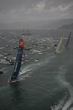
Photo: That’s In Port race one winner Ericsson taking the pin end at the start, on her way to stretching out to a big lead on the left side of the first beat. Photo by Rick Tomlinson.

Santa Cruz Island Closures

Posted by John Callender on November 10th, 2005 at 6:38 am

Santa Cruz Island sunrise

As part of the ongoing effort to remove non-native feral pigs from Santa Cruz Island, the National Park Service is restricting shore access to the eastern part of the island while professional hunters track down and kill the pigs.

I spoke by phone with Yvonne Menard, public information officer for the National Park Service Channel Islands, and she explained that the restrictions have been designed to minimize disruptions to public access. The island has been divided into five zones for the pig-eradication project, with the schedule having been modified so the closure in the most-visited Park Service portion of the island occurs during the winter months.

Between November 1, 2005 and March 20, 2006, no overnight camping will be allowed in the national park (overnight camping by private boaters is never allowed in the non-Park Service portion of the island). The landing area and shore facilities at Scorpion Cove will be open to the public from 9:00 a.m. to 4:00 p.m. on Saturday and Sunday, as will the hiking trails between there and Cavern Point and Potato Harbor. The park property at Prisoner’s Harbor will remain open 7 days a week, again between the hours of 9:00 a.m. and 4:00 p.m. Otherwise, the Park Service portion of the island is closed to the public until March 20.

For more details on the Park Service closure, see this news release at www.nps.gov: Feral pig eradication begins on park property on Santa Cruz Island.

For those of us lucky enough to have access via our own boats to other parts of the island, the situation is slightly different. Going ashore on the western three quarters of the island, which is operated by the Nature Conservancy, requires prior purchase of a per-vessel landing permit. Currently the cost is $15 for a 30-day permit, or $40 for a calendar-year permit. Since the pig hunt began in March, 2005, permit holders may not hike inland; they may only explore the island’s coastline and beaches.

In addition, certain parts of the Nature Conservancy portion of the island are currently closed to all landings. As of September 1, 2005, beach closures are in effect at the following locations:

  • Ladys Harbor
  • Diablo Anchorage
  • Frys Harbor
  • Platts Harbor
  • Twin Harbors
  • Pelican’s Beach
  • Tinker’s Cove
  • Alamos Beach
  • Laguna Harbor
  • Playa Larga
  • Posa Anchorage
  • Sauces Beach
  • Christy Beach

The following map shows the beaches currently closed:


For more information, see the following online resources:

Free Raster Charts from NOAA? Not Yet, Sadly

Posted by John Callender on November 9th, 2005 at 6:00 am

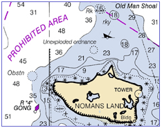
nautical chart example

A lot of extremely useful information for boaters is produced by government agencies. Since those agencies have a mandate to share that information with the public, and since free distribution via the Internet seems like an obvious way to do that, one would think that a lot of government information would be available that way.

Well, some of it is. I previously wrote about the data available from NOAA weather buoys, and I’ll probably be writing in the not-too-distant future about how cool it is that one can download current Coast Pilots and Local Notices to Mariners.

So you’ll understand that I was really excited by this article in the current issue of BoatUS by Elaine Dickinson: Charts go PC.

As digital technology moves forward at an ever-increasing speed, a bewildering array of chart products are out in the consumer marketplace, with more coming. Now, in a major development, the National Oceanic and Atmospheric Administration (NOAA) will soon, if it hasn’t done so by presstime, make its full suite of 970 raster electronic charts of U.S. waters available free to the public via the Internet.

Up until now, boaters with navigation software had to purchase their charts from a vendor or pay a vendor for a subscription to a chart updating service. Now all of the charts, plus weekly “patches” of chart updates, can be downloaded from NOAA at no cost. The site is www.nauticalcharts.noaa.gov.

The change has come about following the expiration of an exclusive agreement between NOAA and Maptech, a private company that co-developed the electronic chart format with the federal agency. Maptech’s Cooperative Research and Development Agreement ended in June, freeing up NOAA to release electronic raster charts to the public since it co-owns the resulting format and files.

Woohoo! Pretty exciting, eh? (At least for a navigational obsessive like me.) Sadly, it turns out that the new program is not yet up and running. After clicking around for a while on the NOAA web site, and finding only information relating to the old, non-free distribution agreement with Maptech, I used the site’s feedback form to ask what was up. The next day I got the following response:

Mr. Callender,

The Office of Coast Survey (OCS) does intends to distribute Raster Nautical Charts (RNCs) and updates for free over the Internet in the same manner as our distribution of Electronic Navigational Charts (see http://nauticalcharts.noaa.gov/MCD/enc/index.htm).

In addition, OCS also anticipates establishing a program by which commercial, value-added providers will be able to download RNCs for free; reformat, encrypt, and/or packaged them with additional data or services; and eventually sell the resulting product for whatever price the market will bear. By adhering to a simple set of NOAA specified practices, these RNCs will retain their official status.

However, as of today (November 7, 2005) a commencement date for either program has not been established by the Office of Coast Survey.

So, no free raster charts for now. But soon, hopefully.

Update: I also wrote to BoatUS magazine to see if they had any more information, and Assistant Editor Michael Vatalaro responded as follows:

NOAA pushed back the release of the raster charts after we went to press. It was supposed to be Mid-October. Right now, they are saying Mid-November. Please check back with them in a few weeks or watch our web site for an update.

So, again with the ‘woohoo!’

Later update: The charts are now available. Yay! See Downloadable Raster Charts Available Free from NOAA.


Weblog Home | Buyer's Guide | Weather | FAQ | Contact