Archive for 'Navigation'

New Chart Edition for 18772, ‘Approaches to San Diego Bay’

Posted by John Callender on January 8th, 2006 at 8:17 am

Part of \'Approaches to San Diego Bay\', chart 18772

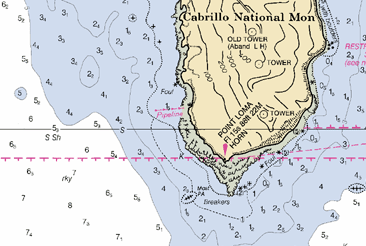
The latest Local Notice to Mariners for the 11th Coast Guard District contains some important navigational updates for San Diego sailors in particular.

  • The Point Loma Light’s sound signal is currently inoperative.
  • Chart 18772, ‘Approaches to San Diego Bay’, has a new edition out, “due to numerous Notice to Mariners changes.”

On the new chart, more information (including the downloadable raster version) should be available soon from NOAA’s nautical charts web site. As of the time of this posting, though (0854 PST, 8 January 2006), they’re still offering the previous edition (from 2003) for download.

I actually have really fond memories of working on that chart. I talked about one time in particular in a book I wrote most of, but never (yet) got published, called A Distant Sea. At some point I might post some of that book on this site, since it would be nice to let that material see the light of day.

The story regarding that chart involved the finish of the San Clemente Island race one year. That race started off Dana Point, left San Clemente Island to port, and finished in San Diego. This would have been in the mid-1970s, and I was racing on my dad’s Columbia 52 Victoria. The approach to San Diego was made in the morning, after racing all night from the southern tip of San Clemente with no navigational aids to speak of. (This was pre-GPS, and we didn’t have anything fancy like a radar or LORAN.) It was pretty hazy that morning, so the approaching shoreline wasn’t visible, and it was a tricky navigational problem to know just where to aim to hit the #3 buoy (the last turning mark before the finish off Point Loma). We were doing pretty well in the race, with lots of competitors close to us, so there was a lot of pressure to make the right call; coming in in the wrong place and having to make a big course correction at the last minute would surely have cost us positions.

I’ll leave it until later to post the whole story. But the (supremely satisfying, for me) result ended up involving some careful dead reckoning, a running fix on the Point Loma radio beacon, and (especially) my dad’s uncanny ability to accurately estimate the distance of a visible landmark.

More Free Charts

Posted by John Callender on November 26th, 2005 at 9:35 am

Maptech, the company that used to sell NOAA’s raster charts, is now offering its own free online distribution of them: Free boating charts. The interface seems to be a little slicker than the one at NOAA’s site, so go thou and download likewise.

Downloadable Raster Charts Available Free from NOAA

Posted by John Callender on November 22nd, 2005 at 6:59 pm

Catalina\'s West End

I wrote previously about NOAA’s intention to make raster versions of their nautical charts available over the Internet (Free raster charts from NOAA? Not yet, sadly). Well, guess what? The day is here! Woohoo!

From the Office of the Coast Survey: NOAA raster navigational charts.

A fundamental tool of marine navigation, NOAA’s Raster Navigational Charts (NOAA RNCs) are produced by scanning at high resolution the original color separates, which are used to print the paper charts.

I feel a little like Steve Martin’s character in The Jerk, when he goes running down the street shouting, “The new phone book is here! The new phone book is here!” I have a long history with NOAA’s charts. As a teenager I was a hard-core navigation geek. I read Bowditch cover-to-cover, and used to lobby my Dad for upgraded charts to replace the tattered ones (some of them older than I was) that he kept on his boat. I loved those charts. Even now, when GPS has rendered the close, personal relationship I used to have with them somewhat obsolete, I still have a soft spot for them. The thought of being able to just sit in my home and download every single one of them (well, almost every single one; the site mentions a few that have problems currently), is just… I don’t know. Something.

Something good. :-)

Elaine Dickinson, managing editor of BoatUS Magazine, was kind enough to send me an email alerting me to the availability of the charts at the NOAA site. The files are available via a fairly clunky Java-based interface, and arrive in BSB format, which apparently is a format developed by Maptech, the former vendor of the charts whose licensing agreement recently expired.

I was able to find a nifty open source library called libbsb to read the charts, and shortly thereafter I was scrolling happily through a 12,451 x 9,390 pixel PNG of 18740, San Diego to Santa Rosa Island, a chart I’ve probably spent more time with than any other. The image above is a reduced version of one part of it; here’s a full-scale sample of it to give you an idea of what it’s like.

Apparently the program of making the charts available is still in the beta stage. At least, that’s the impression I get from the following email from Captain Jim Gardner, chief of the Marine Chart Division at NOAA:

NOAA’s Free Raster Chart Server is now up at:
http://Nauticalcharts.noaa.gov/

There is a limit of 100 charts that can be selected and downloaded at one time. With selection of any chart you can get:

1. The BSB formatted raster chart, updated for most recent Notice to Mariners (NTMs).

2. A cumulative patch file of all NTMs released since the last edition of the chart has been published. This file is intended to bring a current edition raster completely up-to-date.

3. Or both

Note: The server has been experiencing occasional downtime recently. Please try again if you are having problems.

Baring any serious problems we hope to announce this on December 1.

I’m looking forward to figuring out how I can best integrate the charts with the offerings on this site; at a minimum, you can expect to find some smallish chunks of them adorning the Locale pages in the Buyer’s Guide.

So, did I mention how excited I am about this? Woo!

Free Raster Charts from NOAA? Not Yet, Sadly

Posted by John Callender on November 9th, 2005 at 6:00 am

nautical chart example

A lot of extremely useful information for boaters is produced by government agencies. Since those agencies have a mandate to share that information with the public, and since free distribution via the Internet seems like an obvious way to do that, one would think that a lot of government information would be available that way.

Well, some of it is. I previously wrote about the data available from NOAA weather buoys, and I’ll probably be writing in the not-too-distant future about how cool it is that one can download current Coast Pilots and Local Notices to Mariners.

So you’ll understand that I was really excited by this article in the current issue of BoatUS by Elaine Dickinson: Charts go PC.

As digital technology moves forward at an ever-increasing speed, a bewildering array of chart products are out in the consumer marketplace, with more coming. Now, in a major development, the National Oceanic and Atmospheric Administration (NOAA) will soon, if it hasn’t done so by presstime, make its full suite of 970 raster electronic charts of U.S. waters available free to the public via the Internet.

Up until now, boaters with navigation software had to purchase their charts from a vendor or pay a vendor for a subscription to a chart updating service. Now all of the charts, plus weekly “patches” of chart updates, can be downloaded from NOAA at no cost. The site is www.nauticalcharts.noaa.gov.

The change has come about following the expiration of an exclusive agreement between NOAA and Maptech, a private company that co-developed the electronic chart format with the federal agency. Maptech’s Cooperative Research and Development Agreement ended in June, freeing up NOAA to release electronic raster charts to the public since it co-owns the resulting format and files.

Woohoo! Pretty exciting, eh? (At least for a navigational obsessive like me.) Sadly, it turns out that the new program is not yet up and running. After clicking around for a while on the NOAA web site, and finding only information relating to the old, non-free distribution agreement with Maptech, I used the site’s feedback form to ask what was up. The next day I got the following response:

Mr. Callender,

The Office of Coast Survey (OCS) does intends to distribute Raster Nautical Charts (RNCs) and updates for free over the Internet in the same manner as our distribution of Electronic Navigational Charts (see http://nauticalcharts.noaa.gov/MCD/enc/index.htm).

In addition, OCS also anticipates establishing a program by which commercial, value-added providers will be able to download RNCs for free; reformat, encrypt, and/or packaged them with additional data or services; and eventually sell the resulting product for whatever price the market will bear. By adhering to a simple set of NOAA specified practices, these RNCs will retain their official status.

However, as of today (November 7, 2005) a commencement date for either program has not been established by the Office of Coast Survey.

So, no free raster charts for now. But soon, hopefully.

Update: I also wrote to BoatUS magazine to see if they had any more information, and Assistant Editor Michael Vatalaro responded as follows:

NOAA pushed back the release of the raster charts after we went to press. It was supposed to be Mid-October. Right now, they are saying Mid-November. Please check back with them in a few weeks or watch our web site for an update.

So, again with the ‘woohoo!’

Later update: The charts are now available. Yay! See Downloadable Raster Charts Available Free from NOAA.


Weblog Home | Buyer's Guide | Weather | FAQ | Contact